Chenani State in Historical Records: Tracing the history through Textual Sources
By: UDEY VEER ANTHAL
Located in the lower Himalayan belt of
the Duggar region, Chenani occupies an important place in the history of Duggar
region. It was a prominent state among the twenty two hill states of the Duggar
region, participating in a fragmented political system during the medieval
period. Today, it is largely known as an important sub-division of Udhampur,
having many tourist destinations as well as temples such as Sudhmahadev temple.
Historical references scattered across Persian chronicles, travel accounts,
colonial surveys and modern historical works indicate that Chenani once
functioned as an important hill principality.
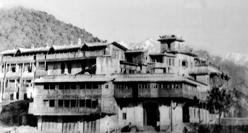
A review of these references across
time helps situate Chenani within the broader political landscape of the
western Himalayan hill states.
Mughal Period References
One of the earliest textual windows
into the political geography of the Duggar region appears in the Mughal
administrative compendium Ain-i-Akbari compiled by the court historian
Abu'l-Fazl during the reign of the Mughal emperor Akbar in the late sixteenth
century.
The Ain-i-Akbari
provides detailed information about the administrative divisions of the Mughal
Empire and the hill tracts bordering the plains. In its references to the hill
territories around Jammu, the text records the existence of numerous small
chieftainships occupying the mountainous terrain between the plains of Punjab
and the Kashmir Valley. Although the work does not always provide extensive
details about each minor state, historians studying the Duggar hills have interpreted
these references as evidence of a politically fragmented region composed of
several small principalities, among which Chenani was one. As per the details given in Ain-i-Akbari, Chenani had an area of
6201 bighas and a revenue of 2,40,000
dams. The infantry of the state is
given as thirty in number and Cavalry at two hundred. The state was ruled by
the Hatiyalah (Anthal
) caste. The reference of Chenani state in Ain-i-Akbari
establishes it as an independent principality. It further establishes it as
an important state, worthy of being mentioned among the other important states
during the Mughal period.
Another Mughal source, the imperial chronicle Akbarnama, also compiled by Abu'l-Fazl, reflects
the Mughal court’s awareness of the hill chiefs inhabiting the Himalayan
foothills adjoining Jammu. These chronicles collectively suggest that by the
sixteenth century the region already contained multiple semi-autonomous hill
polities whose rulers maintained varying degrees of interaction with the Mughal
administration. Abul Fazl mentions that a confederacy of Rajput States of Jammu
hills was made against the Mughals when Akbar started the process of
establishment of his sovereignty in Jammu hills. The state of Chenani was among
these states which offered resistance to the advance of Akbar forces into the
hill states.
Early European
Travel Accounts
In the late eighteenth century,
European travellers passing through northern India began documenting their
journeys across the Himalayan routes. Among them was the British traveller
George Forster, whose journey to Central Asia in the 1780s took him through
northern India and the Himalayan belt.
Forster’s travel
narrative, later published as A Journey from Bengal to England, includes
descriptions of the mountainous routes linking Kashmir with the plains of
Punjab. While his account focuses primarily on travel conditions, geography and
local society, it also reflects the existence of several small hill
principalities occupying strategic passes and valleys. These scattered
references illustrate the political mosaic of the Duggar hills, within which
states such as Chenani operated. Travel narratives such as Forster’s are
valuable because they provide an outsider’s observation of the region at a time
when the hill states retained significant local authority. George Forster writes in A Journey From Bengal To England, “At the vicinity of Nagrolah
(Nagrota) commence the districts of the Chinnanee chief, a dependent on Jambo,
who possesses a revenue of about a lack of rupees. This state does not remit
any tribute to his superior, but assists his government with a quota of troops
in the event of exigency; and conformably to this tenure he now serves in the
campaign against the Sicques
(Sikhs).” He further writes, “On the 20th, at Chinnanee; a neat and
populous town, situate on the brow of a hill; at the foot of which, on the
eastern side, runs a rapid stream, passing to the left.” The account of Chenani
given by George Forster establishes the fact that the state was virtually
independent at the time of his visit. The rulers did not pay any tribute to any
superior either, which strengthens the fact the rulers of Chenani had full
autonomy over the region they ruled. Further, he mentions that the ruler of
Chenani was participating in campaigns against the Sikhs. It establishes that
the rulers of Chenani were full of valor and warrior like qualities and they
never surrendered to the outside power. They always resisted the outside
control and domination over themselves and remained successful in establishing
independence and autonomy.
Another
important European traveller whose writings shed light on the Himalayan regions
adjoining Jammu was the British explorer Godfrey
Thomas Vigne. Vigne travelled extensively across northern India and the
western Himalayas in the 1830s, including journeys through Kashmir, Ladakh
and the hill regions around Jammu. His
observations were later published in the travel narrative Travels in
Kashmir, Ladakh, Iskardo, the Countries Adjoining the Mountain Course of the
Indus and the Himalaya North of the Punjab.
In his
account, Vigne described the rugged hill tracts lying between the plains and
the Kashmir Valley, referring to the existence of numerous small hill
chiefships scattered across the region. These principalities were typically
governed by local Rajput rulers who exercised authority over limited mountainous
territories. While Vigne’s narrative is primarily concerned with geography,
routes of travel, and local customs, his descriptions help illuminate the
broader political landscape of the Duggar hills during the early nineteenth
century. Within this context, the hill principality of Chenani formed part of the chain of small states
situated along the routes connecting Jammu with the interior Himalayan valleys.
G.T Vigne
writes in Travels In Kashmir, Laddakh And
Iskardo, “Chinini is a large and neat village, overlooked by the old
palace- if it deserves such a name- of its legitimate Rajahs. The river Taui
has its sources in the mountains to the eastward of it, and comes rattling down
the ravine, which conducts its stream to the foot of the eminence on which the
village is built, and after wards it flows, in a straight course, towards the
plain, which is about seventeen miles distant.” G.T.Vigne tells us about the
boundaries of the state. He writes, “The territories of the Chinini Rajah
extended from Dodhera on the north west, and south ward to the village of
Bari.” Travel accounts such as Vigne’s are particularly valuable because they
capture the condition of the region at a time when the hill states still
retained a measure of local autonomy, shortly before the consolidation of
political authority under the Dogra rulers of Jammu
and Kashmir.
Nineteenth-Century
Colonial Surveys
During the nineteenth century, British
administrators and scholars undertook systematic studies of the geography,
archaeology and political history of the Himalayan regions. One of the most
important figures in this context was the archaeologist and historian Alexander
Cunningham.
Cunningham’s
surveys of northern India and the western Himalayas frequently mention the
existence of minor hill states situated around Jammu. In his discussions of the
region’s historical geography, Cunningham describes these principalities as
small Rajput chiefships occupying the rugged hill terrain between the plains
and the Kashmir Valley. Chenani is counted among such states that retained
their local ruling families while functioning within a wider regional political
framework. Sir Alexander Cunningham, in his book,
The Ancient Geography of India gives
the oldest classification of these states which divided them into three groups,
each named after the most powerful state which was the head of the
confederation. These were Kashmir, Duggar
and Trigarta. The state of Chenani
was a part of the Duggar states.
According to Sir Alexander Cunningham, the following states belonged to the
group.
Jammu, Bhao, Rihasi (Reasi), Akhnur, Poonch,
Rajouri, Kotli, Bhimbar, Khariali, Kishtwar, Bhaderwah, Chenani, Bandralta,
Samba, Jasrota, Trikot, Mankot, Badwal, Billawar.
These surveys are significant because
they attempt to document the historical geography of the Himalayan foothills
using both textual sources and field observations.
Historical
Studies of the Hill States
Modern historical scholarship has
further examined the complex political structure of the Himalayan hill states.
In their well-known studies on the hill states of northern India, historians J.
Hutchison and J. Ph. Vogel compiled genealogical and historical information
about numerous principalities located in the western Himalayan belt. The mountainous area of the Punjab region
retained a distinct political condition of its own till the nineteenth century.
From the Indus to the sources of the Ganges, the outer ranges of the Punjab
Himalaya were divided up among numerous native states, each under its own
hereditary chief. Some of these principalities were founded as late as the
fifteenth or the sixteenth century, while others dated from the early centuries
of the Christian era, and two at least- Kashmir and Trigarta were still older. Regarding the boundries of Chenani,
Hutchison and Vogel gives us the information that Chenani state was bounded on
the north by Chinab river, on the East by Bhaderwah, on the South by the
Gaddian Dhar and Bandralta, and on the West by the Biroh Nala and Bhoti. It
includes two main portions, separated by the Dodhera or Ladha ka Dhar-one in
the Upper Tawi valley and the other in the Chinab valley.
Although their work primarily focuses
on the hill states of the Punjab Himalayas, it also acknowledges the existence
of smaller principalities scattered across the Duggar hills. Chenani is
generally situated within this wider constellation of Rajput-ruled hill states
that governed relatively small territories while maintaining alliances with
larger regional powers.
Among
the modern historians who worked on the history and culture of Himalayan hill
states in general and history and culture of Chenani in particular was Prof. S.D.S
Charak. He has done extensive research work on the history and culture of
Chenanni state. He fixes the boundaries of Chenani as Jammu on the west, Bhoti
on the north, Bhaderwah on the north-east, Basohli on the east and Mankot on
the South. He has also discussed the polity, socio-economic conditions and
culture of Chenani in detail in his work History
and Culture of Himalayan States, Volume 6.
Conclusion
Although Chenani, along with many
other hill states, rarely occupies a prominent place in major historical
narratives, scattered references across a wide range of sources—from Mughal
chronicles and European travel accounts to colonial surveys and modern
historical studies—demonstrate that it once formed part of the intricate
network of hill principalities that characterized the political geography of
the Duggar region.
These textual traces remind us that
the history of the western Himalayas was not shaped solely by large kingdoms
and empires but also by numerous smaller states whose presence can still be
recovered through careful reading of historical records


Comments
Post a Comment